Home
/
Why AI-powered geospatial analytics is propelling the future of utility vegetation management
Why AI-powered geospatial analytics is propelling the future of utility vegetation management
Guest/partner contributor
Posted on: 16 August 2024
Our nation's utility infrastructure, especially in rural areas, is vulnerable if the correct protections are not implemented, writes Sean Dogegan, President and CEO of Satelytics.

America's utility infrastructure, especially in rural areas, is vulnerable if the correct protections are not implemented, writes Sean Dogegan, President and CEO of Satelytics.
The slightest spark – say a tree growing in the wrong location – can trigger power outages, wildfires, and infrastructure damage. This potential is far from a remote concern: according to the Federal Energy Regulatory Commission (FERC), vegetation is one of the leading causes of electric service outages. When vegetation around power lines is not monitored, it can spell disaster for both businesses and surrounding communities.
It's not surprising, then, that utility vegetation management is projected to swell to a nearly $40 billion industry by 2029: few services are more urgently needed and have more of an impact on Americans' day-to-day lives.
That urgency helps explain the drive towards innovation in the industry, with utility organisations working in concert with technology companies to marshal in cutting-edge technology to improve vegetation management efforts nationwide and ensure that communities are kept safe.
One notable example of this can be seen in the recent work from cloud-based geospatial analytics company Satelytics. The company worked with a large energy company and used the latest AI and machine learning developments to apply algorithms designed to help determine where and when to cut down trees and vegetation encroaching on utility lines with a high level of granularity.
This project – performed in and around Indianapolis – took into account several considerations, including proximity to the corridor and wire zone, plus tree height, health and speciation.
The results of this project were encouraging and provided a timely glimpse into the direction of the industry at large in the coming years.
The first assessment: High-level analysis
The first assessment, conducted in October 2022, was tasked with determining whether any trees were growing into danger zones, divided into two categories – wire zones and strike zones.
The wire zone designates the area directly under the widest portion of a transmission line. In this case, the wire zone was taken into account by measuring the distance between the pole and line. When trees grow into that wire zone, there is an increased risk of negative consequences like loss of power and wildfires.
In addition to wire zones, a clearer picture of strike potential is needed, i.e. identifying trees that, while rooted outside the wire zone, still potentially posed a threat to electrical infrastructure.
Heat and wind cause power lines to sag and sway, bringing them outside the designated wire zone and potentially into contact with vegetation. As a result, line sag and sway are taken into consideration when calculating strike zones. Threats within this strike zone present the same increased risks posed by wire zone threats.
The first results: Fall 2022
This initial analysis in Fall 2022 was staggering, producing 200,651 detections of trees that were within the two danger zones. These alerts were coupled with information on tree height and speciation, thus ascertaining whether the identified trees were evergreen or deciduous.
While the issue of identifying trees that threatened electrical infrastructure was solved, the resulting number of alerts presented a new challenge: how to prioritise 200,651 alerts.
To address this problem, Satelytics developed a heat map to pinpoint ‘hot spots’. On this heat map, areas with a high number of alerts were coloured a bright red, whereas areas with a lower number of alerts were represented in blue. This allowed the customer to better allocate their resources and ensure that the most urgent threats were taken care of first.
The second analysis: Getting granular
The first collaboration in 2022 looked at the big picture: identifying trees in designated danger zones that needed pruning. Effectively, the analysis highlighted the potentially problematic trees within those zones.
The next collaboration between the organisations, which occurred in Summer 2023, brought a new degree of granularity, considering the influence of a tree’s species and noting changes in vegetation growth and health.
Tree speciation, health and growth all influence the degree of risk a tree is to utilities. Some species of trees are more robust than others, able to weather blights and changes in climate. A hearty tree will not fall under normal circumstances, but one more susceptible can become a risk to adjacent electrical infrastructure. Likewise, tree growth over time can increase risk, e.g. trees outside of the previously mentioned danger zones may grow into them, encroaching on infrastructure.
The second round of results: Summer 2023
The first analysis was conducted after the leaves in Indianapolis had fallen, while the second was conducted while the trees had all their leaves. Both stages offer the chance to collect important data, but the benefit of analysing trees with their leaves is that one can get a much more detailed sense of tree health.
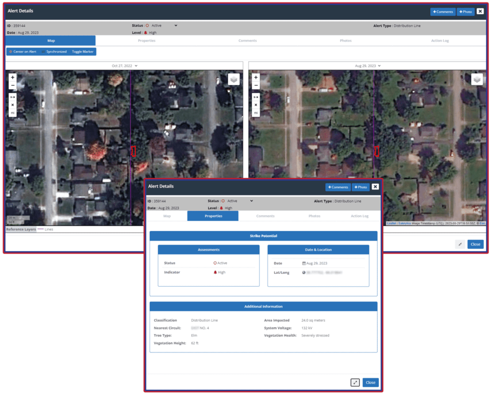
Accordingly, the employed algorithms assess all vegetation factors with unprecedented granularity. Through analysing the spectral signatures of individual trees, the customer was able to receive specific data about individual trees, i.e. not just ‘deciduous’ or ‘evergreen’ but for example ‘this is an unhealthy, 49-foot silver maple tree’.
This time, the analysis resulted in 49,505 alerts, and these were also prioritised to optimise field crew intervention.
This process was significantly aided by developing a ‘circuit risk’ product, for an optimised, rotating schedule of tree-cutting, ensuring the highest-risk circuits would be worked on first.
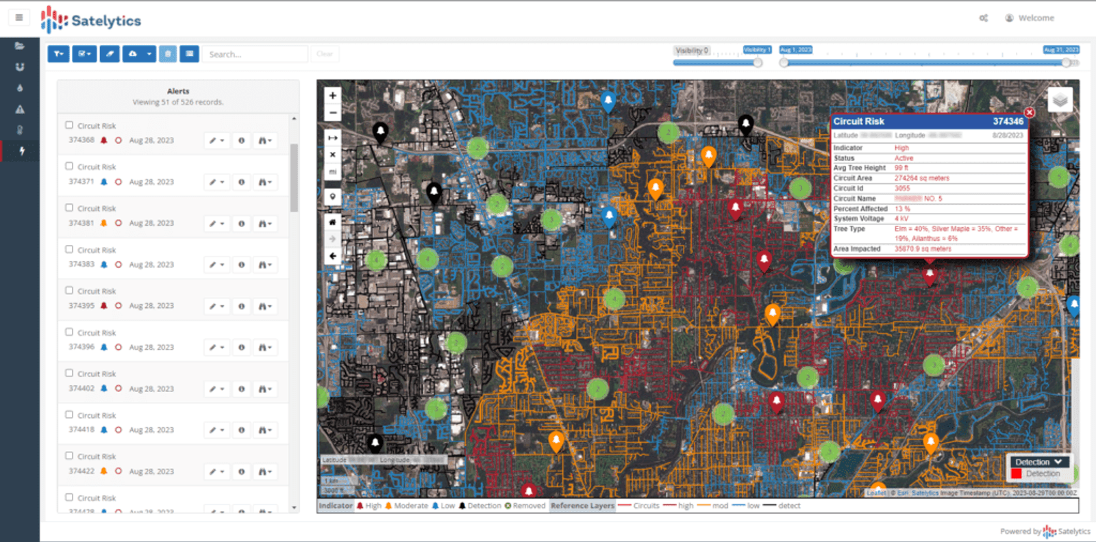
These analyses enabled the companies to grade the risk level of each circuit, factoring in the percentage of stressed versus healthy trees, which allowed crews to direct their attention to those trees that posed the biggest threat to electrical infrastructure.
Why utility vegetation management matters
The kinds of problems identified by the results of these analyses would have been impossible without the use of AI/ML algorithms. Inevitably, traditional methods are limited by available manpower: even the most lavishly resourced utility companies cannot afford to spend the billions it would require to hire and maintain a staff large enough to identify every problematic tree in a given area.
The success of this joint initiative is an affirmation of the motto, ‘The more data, the better’. By gathering and instantaneously analysing vast quantities of data, AI/ML-enhanced utility vegetation management initiatives can provide a level of clarity that was inconceivable just a few short years ago.
The damage caused by untended vegetation is incalculable; a single neglected tree can cause consequences that not only damage surrounding homes but claim lives. The cost to communities – not to mention that to liable businesses – is too high for utility companies not to embrace the latest in vegetation management technology.
About the author
Sean Donegan is the President and CEO of Satelytics. He brings over thirty years of technology and software development experience to the company from a career focused on building companies through creativity and innovation and recruiting highly effective teams to solve customers’ toughest challenges.